
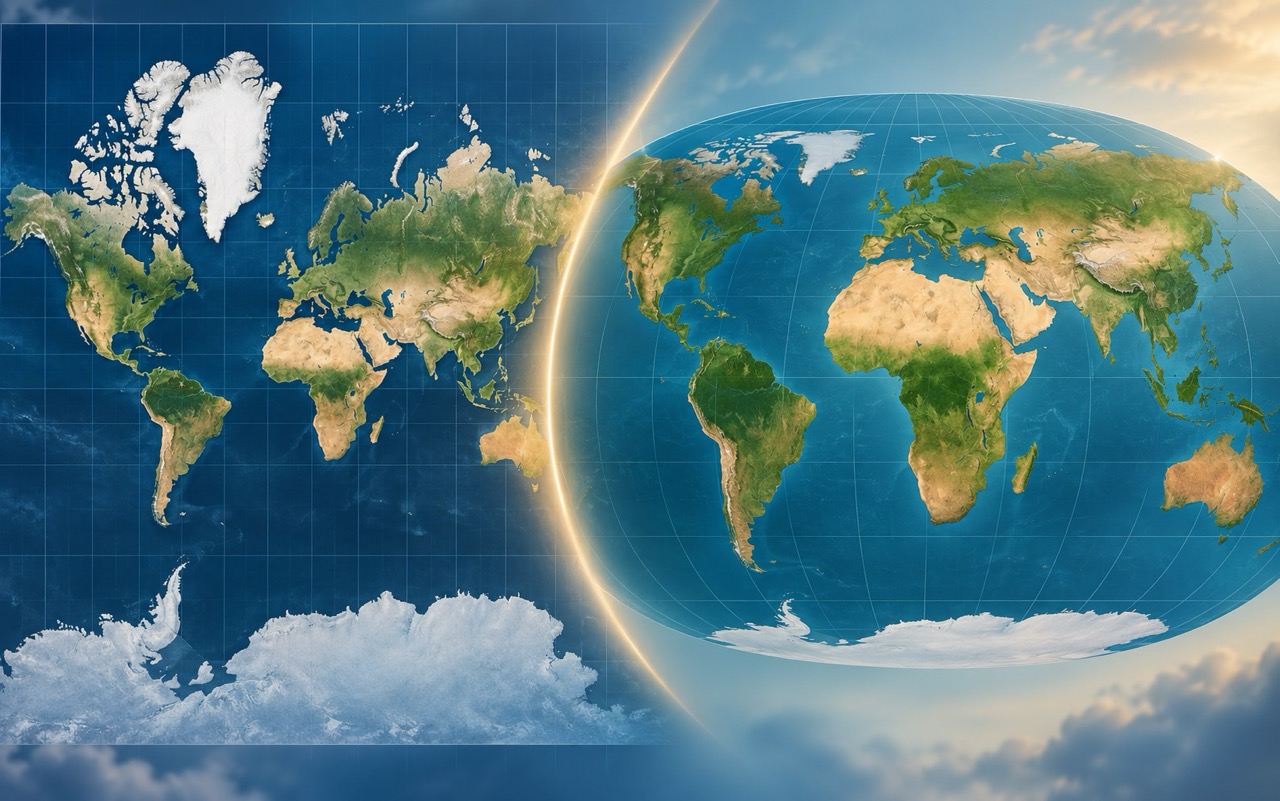
The world map familiar from school atlases, wall maps and the internet may be about to undergo one of its biggest changes in centuries. On September 4, 2026, the UN General Assembly backed the “Correct the Map” initiative, which calls for wider use of map projections that show the true relative sizes of continents. The main focus is the Mercator projection, introduced in 1569.
The Mercator projection is not disappearing entirely, nor has the UN banned it. However, the new resolution recommends using projections such as Equal Earth for world maps because they preserve the correct relative areas of different regions. As a result, Africa will appear considerably larger relative to Europe, North America and Greenland—and much closer to its actual size.
What exactly happened?
On September 4, 2026, the UN General Assembly voted on a resolution entitled “Correct the Map: Rebalancing global cartographic representation and promoting equitable representation of the world’s regions, particularly Africa.” The proposal was submitted by Togo on behalf of the African Group of States.
A total of 164 countries voted in favor of the resolution. The United States was the only country to vote against it, while six countries abstained. However, the resolution does not ban the Mercator projection or require countries to use any specific map.
Its aim is to encourage governments, schools, international organizations, media outlets and technology companies to use projections that preserve true relative areas when depicting the entire world. Equal Earth is one of the recommended options.
What is the Mercator projection?
The Mercator projection is named after cartographer Gerard Mercator, who introduced it in 1569. Its original purpose was not to create the most accurate possible depiction of the size of individual countries.
It was exceptionally practical for navigation.
The Mercator projection preserves local angles. A course following a constant bearing can be shown as a straight line, which was a crucial advantage for sailors. In the 16th century, it was a highly useful technological solution.
The problem arises when the same projection is used as a general-purpose world map and people begin comparing the size of countries based on the image.
Why do some countries look enormous on a Mercator map?
Earth is roughly spherical, while a map on a wall or screen is flat. Transferring the surface of a sphere onto a plane therefore always involves some distortion.
The Mercator projection increases the scale progressively toward the poles. Areas around the equator remain relatively undistorted, while Canada, Russia, northern Europe and Greenland become increasingly enlarged on the map.
This leads to one of cartography’s best-known examples.
Africa versus Greenland
On a standard Mercator map, Greenland can appear almost as large as Africa.
In reality, Africa covers approximately 30.4 million square kilometers, while Greenland covers about 2.2 million square kilometers. Africa is therefore roughly 14 times larger.
This does not mean that the Mercator projection somehow “shrinks” Africa through a mathematical trick. Africa lies mostly at lower latitudes, where distortion is less pronounced. Instead, the projection dramatically enlarges regions closer to the poles, making Africa look smaller by comparison.
What is Equal Earth?
Equal Earth is a much newer map projection. It was created by Bojan Šavrič, Tom Patterson and Bernhard Jenny in 2018 and described in detail in a scientific paper published in the International Journal of Geographical Information Science.
It is an equal-area projection. Its defining feature is that it preserves the relative areas of regions.
If one region is twice the size of another in reality, it will occupy twice as much space on an Equal Earth map. This is precisely the feature that the Mercator projection fails to preserve when depicting the entire world.
Equal Earth was also designed to make the continents look reasonably natural. Its creators took visual inspiration from the popular Robinson projection, which is aesthetically pleasing but does not preserve exact area ratios.
Does that make Equal Earth the “correct world map”?
Not entirely. This is an important point in reports about a “new world map.”
There is no perfect flat map of the entire Earth.
Every projection must sacrifice something. It can seek to preserve area, angles, distances, directions or shapes, but it cannot preserve all these properties across the entire planet at once.
Equal Earth preserves areas more accurately, but at the cost of some distortion in shapes and directions. Mercator, by contrast, preserves local angles very well but dramatically distorts area toward the poles.
The answer to which map is “most accurate” therefore depends on what it is intended to be used for.
Will the new maps be fairer?
If by a fairer map we mean one on which the sizes of countries and continents correspond to their actual areas, then yes.
Equal Earth does not privilege regions by making them appear several times larger simply because of their latitude. Africa, South America and Southeast Asia therefore carry greater visual weight on such a map, while Greenland, Canada, Russia and northern Europe look smaller than they do on the Mercator projection.
The idea of a “fairer map” also has a social dimension. The Correct the Map initiative emerged mainly in African countries, where critics argue that centuries of using Mercator maps may have influenced how people perceive the relative sizes of different parts of the world.
From a purely cartographic perspective, however, this is not a matter of one projection being morally good and another bad. The Mercator projection simply optimizes a different map property than Equal Earth.
Mercator is not going away
Reports about the “end of Mercator” should be taken with some caution. The UN resolution is not legally binding and does not ban the Mercator projection.
There are also situations in which the Mercator projection’s properties remain highly useful. This is especially true for navigation and detailed depictions of smaller areas, where area distortion is less problematic than it is on a map of the entire planet.
Many modern online mapping systems also use a projection known as Web Mercator. Its technical properties offer significant advantages when zooming in on a city or individual streets.
The future is therefore unlikely to be as simple as “Mercator out, Equal Earth everywhere.”
What is likely to change in schools and atlases?
School maps are among the areas where the initiative could have the greatest impact.
If a map is meant to show students how large continents and countries are relative to one another, an equal-area projection makes more sense than Mercator.
A child who spends years looking at a map on which Greenland appears similar in size to Africa may develop a highly inaccurate understanding of the planet’s geographical proportions.
The change will not be immediate, however. The UN has not ordered old atlases to be withdrawn, and individual countries, publishers and schools will have to determine how to implement the recommendation themselves.
France is already moving away from Mercator
Shortly after the UN decision, attention also turned to France. The French Ministry for Europe and Foreign Affairs announced that it was moving away from the Mercator projection in its diplomatic communications and would give preference to the Eckert IV projection.
Eckert IV is not the same as Equal Earth, but it is also an equal-area projection. France will therefore not use the exact model recommended in the UN discussion for all its maps, but has chosen an alternative with the same fundamental property: preserving relative areas.
This also shows that the initiative may not result in a single new universal world map. Instead, it could lead to a gradual shift away from automatically using the Mercator projection everywhere, regardless of a map’s purpose.
How much will the world we are used to change?
Quite dramatically at first glance.
Africa will begin to look enormous—not because the new map enlarges it, but because it will no longer appear alongside greatly inflated northern regions.
Greenland will shrink to a fraction of the size people often imagine it to be. Europe will look smaller relative to Africa. Russia and Canada will no longer occupy such a dominant share of the upper half of the map.
For someone accustomed to the Mercator projection since childhood, Equal Earth may even look “wrong” at first. In reality, this is more a demonstration of how strongly a particular map design can shape our perception of the planet.
Video: Why does Greenland look so large on maps?
This brief explanation of the Mercator projection shows why the difference in size between Greenland and Africa is so dramatically obscured on a traditional map.
So are we getting a new world map?
Yes and no. The geographical data, borders and dimensions of the continents are not changing, of course. What is changing is how we depict them on a flat surface.
The UN vote of September 4, 2026, could provide an important impetus for ending the Mercator projection’s status as the automatic choice for maps of the entire world. Equal Earth and similar equal-area projections can depict the relative sizes of continents far more accurately.
Mercator is unlikely to disappear, however. It can remain a useful tool wherever its particular properties are important.
The biggest change may therefore not be the creation of one “correct world map,” but the realization that no flat map is a neutral window onto the planet. Every projection emphasizes some things and distorts others. After more than 450 years of one projection’s dominance, the world may begin asking more often whether we are using the right map for the right purpose.
Sources
- United Nations – Correct the Map: Rebalancing global cartographic representation and promoting equitable representation of the world’s regions, particularly Africa, A/80/L.104
Official UN document A/80/L.104 - Šavrič, Patterson & Jenny – The Equal Earth map projection, International Journal of Geographical Information Science
Scientific study: The Equal Earth map projection - PROJ – Equal Earth projection documentation
Equal Earth technical documentation - Reuters – UN approves resolution in support of map that shows Africa's true size
Reuters report on the UN vote

Robert
I’m interested in technology and history, especially true crime stories. For three years I ran a fact-based portal about modern history, and for a year I co-built a blogging platform where I published dozens of analytical articles. I founded offpitch so that quality content wouldn’t be hidden behind a paywall.


